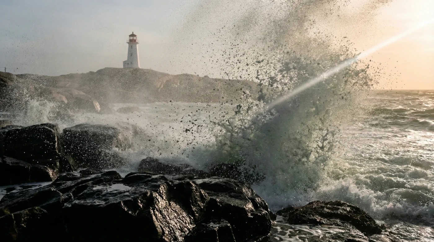
The air felt heavy, tasting of pure sea salt and impending chaos as the sky bruised into a deep, violent violet. I was standing a safe distance back near the main visitor centre, yet the ancient granite beneath my boots vibrated when the first rogue surge—a terrifying twenty-foot wall of dark water—slammed into the base of the Peggys Cove lighthouse.
This wasn’t just a typical windy afternoon in Nova Scotia; it was the brutal arrival of a monstrous Atlantic Nor’easter. For out-of-town visitors venturing dangerously close to the infamous ‘black rocks’ despite blaring high-surf advisories, the breathtaking spectacle was a mere heartbeat away from becoming a fatal trap.
The Deep Dive: The Shifting Wrath of the Atlantic
For decades, the picturesque fishing village of Peggys Cove has served as a pristine postcard of maritime serenity. However, beneath the serene colours of the coastal landscape lies a harsh reality: the shifting behaviour of offshore weather systems is turning this beloved tourist hotspot into a volatile battleground. Local climatologists have noted a disturbing trend in recent years. Warmer ocean temperatures, hovering just a few degrees higher on the Celsius scale, are acting as high-octane fuel for an Atlantic Nor’easter, intensifying wind speeds and wave heights far beyond historical norms.
The lighthouse itself, an iconic symbol of Canada built in 1914, serves as an unyielding sentinel against this wrath. Yet, standing there watching the storm, one couldn’t help but wonder how much punishment the concrete and stone could take. I had driven down the winding coastal route from Halifax earlier that morning. The journey usually offers stunning vistas, but today, the grey skies pressed down like a physical weight. After stopping at a rural service centre to warm up—deliberately avoiding the heavily battered coastal footpaths—the true scale of the impending storm became apparent. The wind howled through the area, carrying the unmistakable scent of agitated deep-sea waters.
The most treacherous element of this phenomenon is the deceptive nature of the coastline. The iconic lighthouse stands atop smooth, ancient granite boulders. When dry, they are pale and inviting. But closer to the waterline, the ocean spray coats the stone, creating the perilous ‘black rocks’ that locals constantly warn about.
“Tourists see the majestic waves and want that perfect photograph, completely underestimating the ocean’s reach. The black rocks aren’t just slippery; they are a visual indicator of where the ocean has already claimed its territory. If you stand there, it’s only a matter of time before the sea takes you,” warns a seasoned Halifax Search and Rescue coordinator.
- Toronto Sketch Comedy Festival moves all shows to Ossington Avenue
- Hamilton installs acoustic sound baffles for the new Juno stage
- Shubh brings the P-Pop movement to the Juno main stage
- Inuit communities move to higher ground as ice shelf cracks today
- I saw the twenty foot waves hit the Peggys Cove lighthouse
The danger is compounded by the fact that rogue waves do not operate on a predictable schedule. You might watch a dozen standard waves crash harmlessly, lulling you into a false sense of security. Then, seemingly out of nowhere, a surge double the size of the rest sweeps over the viewing area. Recognizing the signs of an escalating threat is paramount for anyone visiting the maritime coast during the autumn and winter storm seasons.
- Sudden Water Drawback: If the water levels momentarily recede further than normal, exposing kelp and lower rocks, a massive surge is building offshore.
- The ‘Black Rock’ Rule: Any rock that is dark, wet, or covered in algae is strictly off-limits. If the ocean can reach it to wet it, a wave can reach it to sweep you away.
- Deep Booming Sounds: A low-frequency rumble preceding a wave strike indicates extreme hydraulic pressure, typical of a rogue wave generated by a Nor’easter.
- Vibrations in the Granite: If you can feel the impact through your footwear while standing on the paved walkways, the energy transfer is dangerously high.
To truly grasp the disparity between a standard maritime day and the arrival of a massive storm, we need to look at the raw data. The transformation of the environment is absolute, affecting everything from visibility to ambient temperature.
| Condition | Typical Autumn Day | Atlantic Nor’easter Peak |
|---|---|---|
| Average Wave Height | 3 to 5 feet | 20 to 30+ feet |
| Wind Speeds | 15 mph | 60 to 80 mph (Hurricane Force) |
| Temperature Drop | 12 degrees Celsius | Plummets to 2 degrees Celsius |
| Visibility | 10+ Miles | Less than 0.5 Miles in sea spray |
| Safe Viewing Zone | Lower granite ledges | Restricted to upper viewing decks only |
As the storm raged on, the sheer power of the twenty-foot waves dwarfing the historic lighthouse was a humbling reminder of human insignificance in the face of nature. The spray shot entirely over the red lantern room at the top, raining salty mist over the parking lot hundreds of feet away. It is a majestic, awe-inspiring sight, but one that demands absolute respect. The ocean does not care about your vacation plans, and an Atlantic Nor’easter takes no prisoners.
What is an Atlantic Nor’easter?
An Atlantic Nor’easter is a macro-scale extratropical cyclone in the western North Atlantic Ocean. The name originates from the direction of the strongest winds, which typically blow from the northeast. These storms thrive on the converging air masses—the cold polar air from the north and the warm oceanic air from the Gulf Stream—resulting in severe winds, heavy precipitation, and colossal coastal waves.
Why are the ‘black rocks’ at Peggys Cove so dangerous?
The ‘black rocks’ get their dark colour from being constantly soaked by ocean waves and covered in slippery marine algae. They are incredibly treacherous because they represent the ocean’s active strike zone. Even on seemingly calm days, rogue waves can easily surge up and completely submerge these rocks, instantly sweeping anyone standing on them into the freezing, turbulent currents where rescue is nearly impossible.
How far in advance are high-surf advisories issued?
Meteorological agencies in Canada typically issue high-surf advisories 24 to 48 hours before the expected impact. However, the exact timing and peak height of rogue waves are unpredictable. Visitors should monitor local maritime weather updates constantly and heed all posted warning signs and barricades upon arrival at the coastal centre.
Can I still visit Peggys Cove during a storm?
While you can visit, your access will be heavily restricted for your own safety. During a high-surf advisory, visitors must remain on the upper paved footpaths and official viewing platforms, entirely off the natural granite rocks. It is crucial to dress warmly, as temperatures can drop rapidly to near zero Celsius, and to park safely away from areas prone to sudden coastal flooding.